Bathymetric Surveying
N.E. Parrott Surveys Limited (NEPSL) has established itself as a trusted provider of high-resolution bathymetric surveying services throughout Newfoundland and Labrador. Utilizing advanced hydrographic and GNSS technology, NEPSL delivers accurate underwater terrain mapping to support engineering, environmental, infrastructure, and resource development projects.
Key Responsibilities Include:
· Aerial and Hydrographic Coordination: Integration of bathymetric and topographic surveys with aerial photography for comprehensive mapping of shorelines, waterways, and development zones.
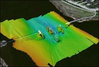
· Digital Terrain and Surface Modeling: Generation of 3D terrain models of lakebeds, rivers, reservoirs, and coastal areas to support planning, design, and environmental assessment.
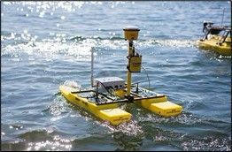
· High-Resolution Bathymetric Mapping: Collection and processing of precise depth data using sonar-equipped vessels or aquatic drones, producing bathymetric charts with contour lines, profiles, and volumetric data.
· Hydrographic and Navigational Surveys: Surveys of rivers, lakes, and marine environments to support:
o Dredging operations
o Flood risk assessments
o Infrastructure siting (e.g., docks, pipelines, bridges)
· Water Level & Depth Profile Monitoring: Establishment of benchmarks and real-time water level monitoring, critical for environmental and hydrological analysis.
· Data Integration & Geospatial Deliverables: Delivery of professional-grade geospatial outputs, including:
o Geo-referenced bathymetric maps
o Digital elevation models (DEM)
o Cross-sectional profiles
o Volume calculations for sediment, dredge, and reservoir studies